
Topics
Anna Kynthia Bousdoukou
The Environmental Costs of War

By Giolanta Ntamadaki and Celia Tsigka
In the shadow of the human toll in the Russia-Ukraine conflict lies a lesser-known casualty: the environment. Since the full-scale invasion on February 24, 2022, emissions soared surpassing 120 million tons of CO2. In Syria, hundred of km2 of tree cover have been lost due to military operations. In Colombia, the decades-long conflict further fueled by illicit coca cultivation has led to significant deforestation, especially in Amazonian regions. The long-lasting impacts of Agent Orange in Vietnam and oil contamination in Kuwait continue to haunt ecosystems.
Human rights abuses and war crimes are outlined and addressed by law. However, when the environment is implicated, what laws apply? Doug Weir, Director at the Conflict and Environment Observatory (CEOBS) [1], a UK charity that collects data, monitors and analyzes conflict-induced environmental harm, stressed the need to consider how the environment features through each part of the conflict cycle. “It can generate conflict, blood diamonds or oil for example. It can also be actively weaponized or damaged during conflict. But it can also be a tool for peacebuilding, recovery and reconciliation”. For CEOBS, technological advancements in environmental assessment are key. “Now we've got social media and satellite remote sensing, we can track issues in almost real time, which is important for getting the environment into the narrative. Because if we can't talk about it, how do we expect other people to care about it?” Weir said.
Ukraine
On February 24, 2022, Russia launched a full-scale invasion of Ukraine [2]. While various organizations have reported the number of troops and civilians killed, the effects on the environment have been neglected in the discourse of war.
As of February 2023, 120 million tons of CO2 [3] were released into the atmosphere as a result of the war. Only if we compare this number to the total pre-war emissions of Ukraine can we understand its significance. According to the European Commission [4], in 2021, the emissions from all sectors in Ukraine’s economy totaled 185.46 million tons of CO2.
According to the graph below, out of the total war emissions, a staggering 50.2 million tons of CO2 is attributed to damaged civilian infrastructure followed by 21.9 million in direct warfare. The sabotage of the natural gas pipelines Nord Stream 1 and Nord Stream 2 has also been a significant emitter accounting for 14.6 million tons. 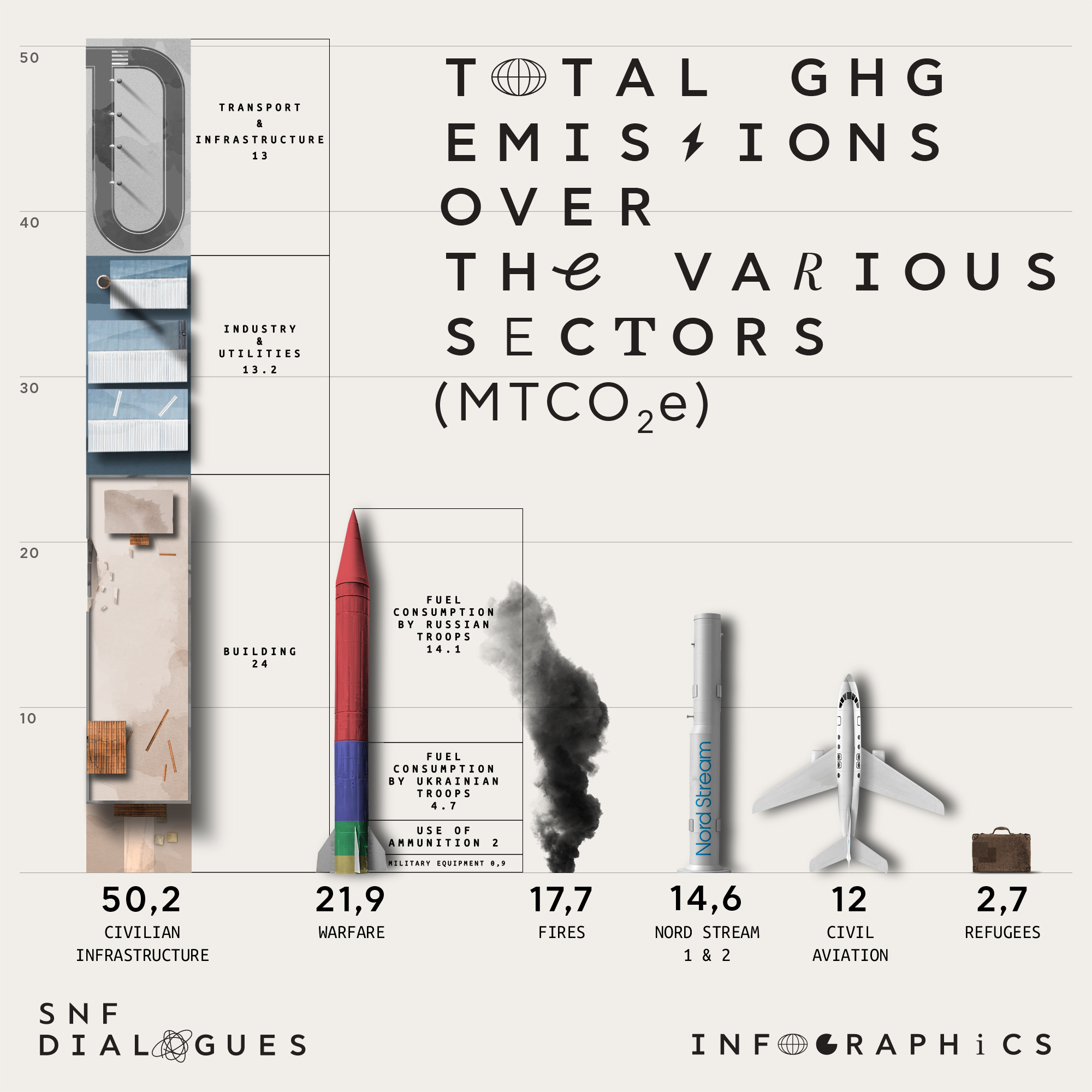
Graph: Total GHG emissions over the various sectors in Ukraine, measured in million metric tons of CO2. Adapted from de Klerk et al. (2023).
However, the above emissions were documented before the Nova Kakhovka Dam collapse, the largest environmental catastrophe in Europe after the 1986 Chornobyl disaster. On June 6, 2023, the Kakhovka Hydroelectric Power Plant, in southern Ukraine suffered an explosion. According to Planet [5], the subsequent collapse of the Nova Kakhovka Dam caused the flooding of 410-420 km2, including 3.5 – 5 km2 of croplands. While whole towns have been destroyed and thousands of animals drowned, the Kherson region was one of the most affected, with 4,000 residents forced to evacuate it [6], as they were left without homes, access to water and electricity.
According to the Ministry of Environmental Protection and Nature Resources of Ukraine [7], more than 80% of water had been lost from the Kakhovka Reservoir, which provided drinking water to over 1 million Ukrainians. Additionally, 800 km2 of natural reserves were flooded as of July 5, destroying the flora and fauna of key National Natural Parks (NNP). Moreover, 456,000 tons [8] of transformer oil ended up in the water, posing the risk of chemical and bacteriological contamination and, thus, the spreading of infectious diseases. The inevitable soil dehydration increased the concentration of harmful toxic substances in the water. The extent of the flood between the 6th and 9th of June can be seen on the map below.
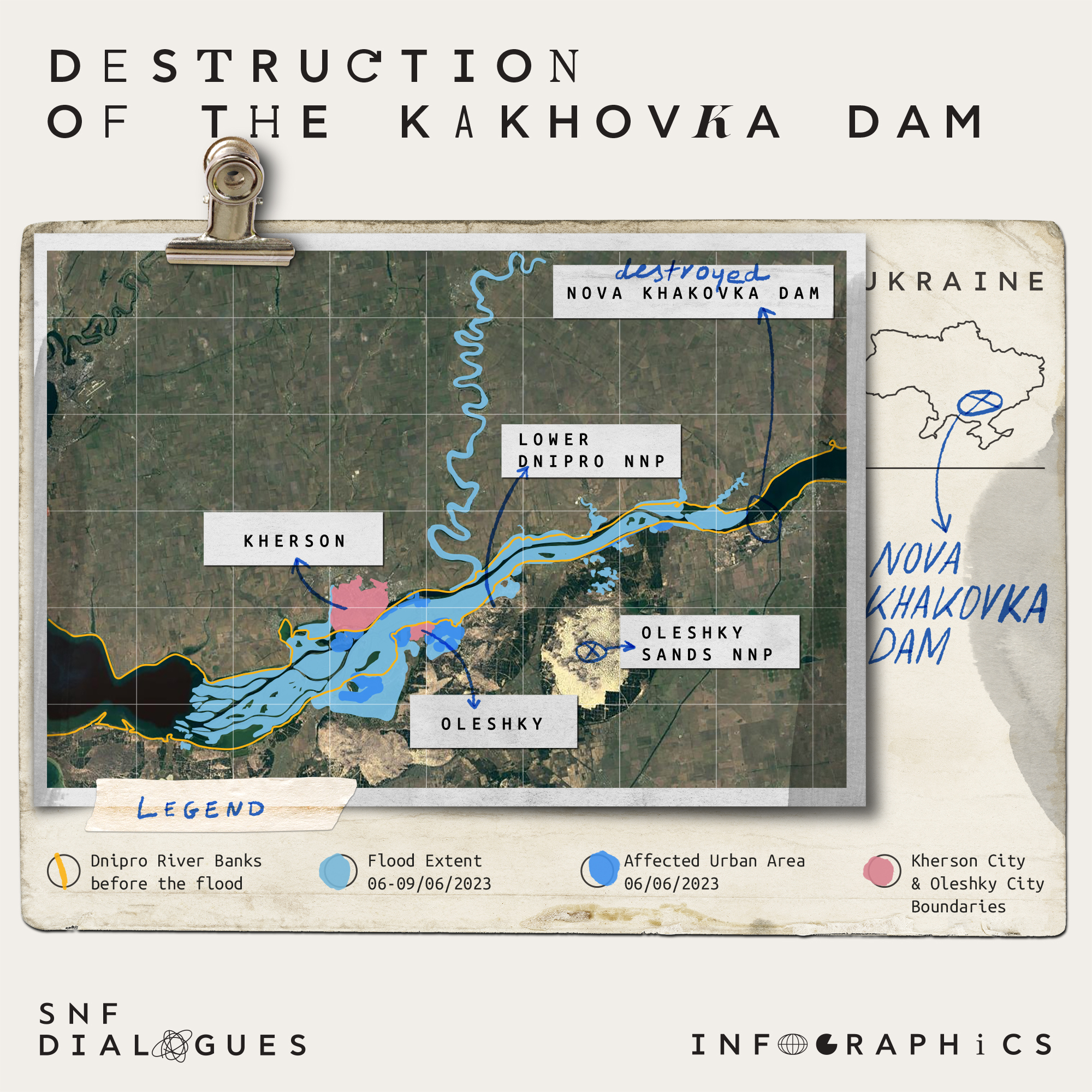 Map 1: Destruction of the Khakovka Dam. Adapted from PAX (2023) and Planet (2023).
Ecocide: environmental damage a crime in its own right
The catastrophic environmental impacts of the Kakhovka Dam destruction in Ukraine provide a stark example of what could be classified as "ecocide." To understand its definition, we turned to Léa Weimann, Co-Lead of the “Youth for Ecocide Law” of Stop Ecocide International [9], a UK-based initiative that has joined the global movement of making ecocide a crime. Stop Ecocide International defines ecocide as the “unlawful or wanton acts committed with knowledge that there is a substantial likelihood of severe and either widespread or long-term damage to the environment being caused by those acts”. Weimann highlights that “historically, as well as still today, environmental damage is largely perceived as incidental, so it's not really seen as a crime in its own right”. Prompted by the recent collapse of the Khakovka Dam in Ukraine, the most recent act of ecocide, she mentioned that “while ecocide is included in Ukraine's domestic Penal Code, but also as a war crime within the Rome Statue, it is too weak to be effectively prosecuted”. Indeed, under the Rome Statute’s Article 8(2)(b)(iv) [10], given the excessively high threshold for the severity and intensity of the environmental damage, no charges have been filed. Additionally, state and corporate actors are excluded from the Article, making it impossible to ensure accountability.
Syria
Pro-democracy protests in southern Syria in March 2011 ended up in an ongoing full-scale civil war. According to the Global Forest Watch [11] and as seen in the maps below, Syria has lost 270 km2 of tree cover, between 2001 and 2022, marking a 26% decrease. In the eastern part of Syria, Lattakia is the most heavily affected region with a tree cover loss of 142 km2, followed by Hama with 773 km2, Idleb with 264 km2 and Tartous with 124 km2. The major cause for this has been fire, representing 153 km2 of tree cover loss, while the year 2012 accounted for a staggering 73% of forest loss.
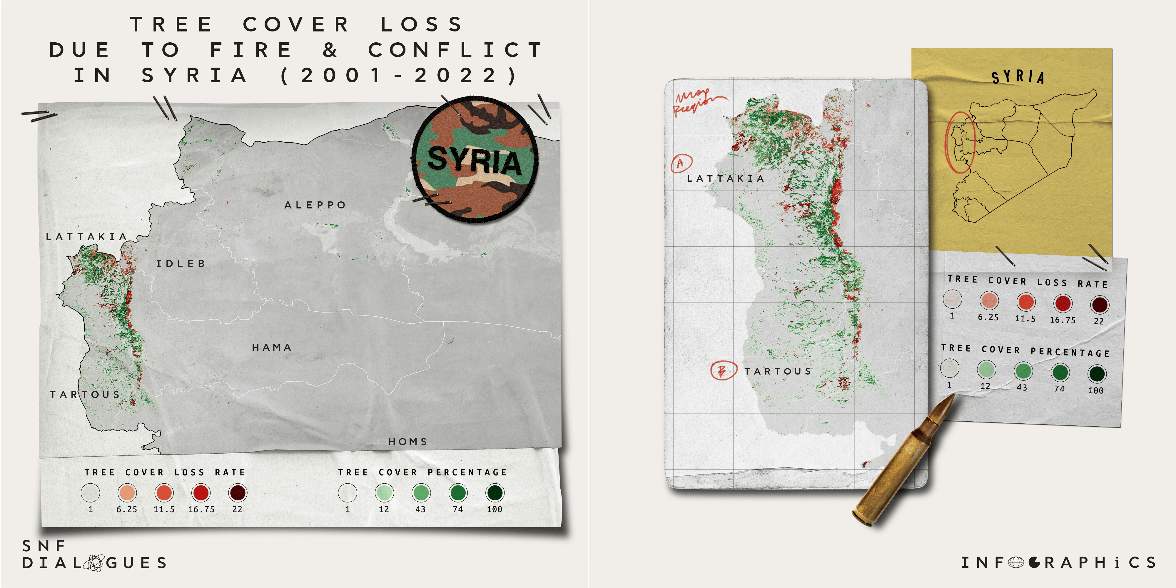
Maps 2 and 3: Tree cover percentage and tree cover loss rate, due to fire and conflict in Syria (left) and in the regions of Lattakia and Tartous, in the western bank of Syria (right), in the years between 2001-2022. Adapted from the Global Forest Watch (2022).
According to a 2023 report by PAX [12], military operations, such as bomb ignitions and intentional forest burning through airstrikes and shelling have caused mass deforestation. During 2011-2021, Lattakia, Hama, Homs and Idleb witnessed tree cover loss of over 36% (453.2 km2) due to fighting between regime forces and rebel groups and due to inadequate forest management. What is more, Kurd Mountains saw 56% forest loss between 2017-2022, especially after the area was taken over by the Turkish-backed Free Syrian Army in 2018. On the other hand, Mount Barsa witnessed a 59% forest loss, between 2018-2021 following the 2018 Turkish-led Operation Olive Branch. Moreover, Syrian offensives against ISIS fighters hiding in the orchards of Palmyra caused a 52% tree cover loss and damage to water and irrigation infrastructure between 2013-2021. Finally, 80% of trees were lost in Damascus due to bombing campaigns during 2010-2018, while Dara’a has lost 90% of canopy cover since 2011, due to intense fighting and the need for firewood.
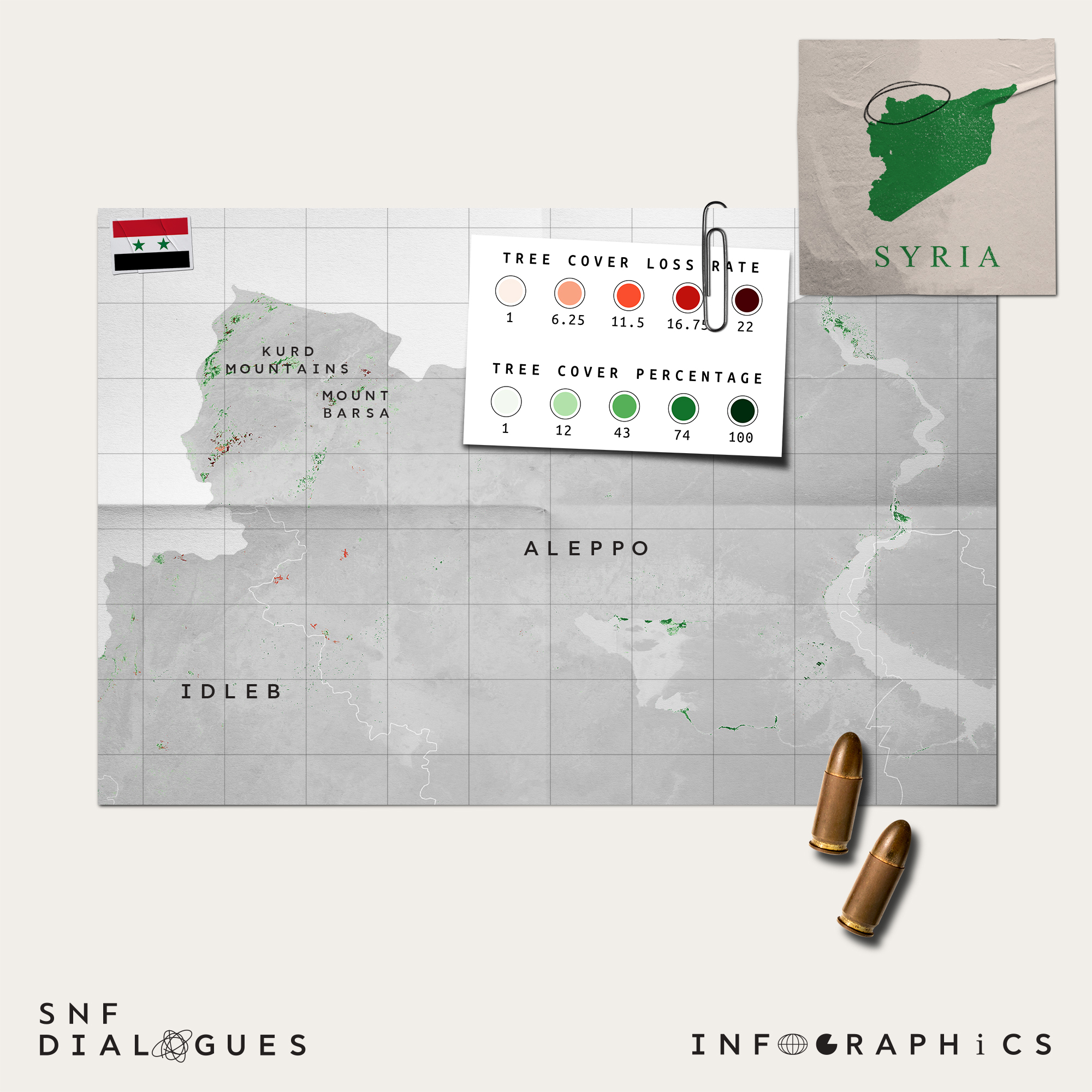
Map 4: Tree cover percentage and tree cover loss rate in the Kurd Mountains and in Mount Barsa, in the northern part of Syria, in the years between 2001-2022. Adapted from the Global Forest Watch (2022).
Since conflict-linked deforestation is a multifaceted phenomenon, various factors should be considered. Among the most important are logging and thinning of firewood for domestic purposes, like cooking and heating. Loggers and traders have taken advantage of the high fuel prices and have created a black market of illegal logging to cater to poverty-stricken families. Charcoal production has also been an alternative to the traditional fuel of mazout, even if most coal production sites are not licensed. Natural forests have also been replaced by new settlements for Internally Displaced People (IDPs), with orchards being used for IDP camps, firewood and housing. Water shortage has further been exacerbated due to widespread displacement. Strikingly, a 0.93% decrease in clean water equals a 1% increase in deforestation [13], showing the interrelatedness between healthy ecosystems and access to resources.
In terms of air pollution, in 2022 the average particulate matter (PM2.5) concentration in Syria was 4 times the WHO annual air quality threshold [14]. Finally, although CO2 emissions [15] have decreased due to the decline of oil and gas-related production, the electricity and heating sector emitted approximately 12 million tons of CO2 in 2019.
Chemical Weapons and the controversy over their destruction
According to SNHR [16], the period December 2012 to August 2023 accounts for 222 chemical attacks in Syria with terrible effects on humans and the environment. After international community pressures, Syria was forced to destroy its chemical weapons. The operation was taken over by the OPCW-UN Joint Mission in 2013 [17], whereby 600 tons of chemical materials were destroyed by neutralization technology aboard the US Maritime Vessel Cape Ray, in the international waters of the Mediterranean. However, environmental organizations like Greenpeace and WWF [18] expressed their concerns regarding the lack of transparency or an action plan in case of an accident (spillage, explosion, etc.).
The issue of Syria’s chemical weapons destruction continues to spark heated controversy, as Syria has still not disclosed [19] information on its remaining chemical weapons stocks, raising concerns about the possibility of a future chemical attack. The lack of transparency in combination with the impunity protecting Assad’s regime highlights the need for a complete, immediate and safe destruction of all types of chemical weapons that pose a threat to both human life and the environment.
Colombia
Between the 1960s and 2016, Colombia experienced over 5 decades of conflict between right-wing groups and left-wing guerillas. In the 1980s, to ensure military and land superiority, the FARC, the biggest left-wing guerilla, controlled 70% of Colombia’s coca crops [20], an indigenous plant with medicinal properties. However, when processed it turns into the highly profitable “white gold”: cocaine.
In 1998, forced eradication policies such as “Plan Colombia” [21] pushed coca cultivation deeper into remote areas of the Amazon and indigenous reserves. While government intervention was rendered unsuccessful, the environment suffered silently, with guerillas and criminal groups seizing lands for conversion to pasture, illegal logging and gold mining to further their power. According to Doug Weir, in an interview with the SNF Dialogues, “in a conflict a lot of the time we think about the direct impact of things exploding or being destroyed, but actually it's the indirect impacts which are more profound and long lasting: the way one sets back a country's ability to protect its own environment through loss of capacity”.
Between 2010 and 2015, the conversion of primary forests into pasture for cattle ranching accounted for 50% of the national deforestation rate [22]. In 2016, the “Final Agreement for the Termination of the Conflict” [23] was signed between the government and the FARC. However, with the FARC out of the picture, a more intense power struggle emerged among illegal groups. By 2016, more than 5% of Colombia’s entire surface area had been deforested [24] due to illegal gold mining and organized crime combined.
According to the 2023 World Drug Report [25], 20% of coca cultivation is located in the Amazon Basin, and between 2000 and 2021 drug-related deforestation claimed 7,350 km2 in Caquetá, 656,000 km2 in Meta, 3,710 km2 in Guaviare and 2,360 km2 in Putumayo. Between 2016-2018, deforestation was increased in 31 Protected Areas [26]. In Meta’s Serranía de la Macarena NNP, deforestation rose from 41 to 91 km2 and in Magdalena’s Santa Marta, from 7 to 30 km2 [27], due to post-conflict land-grabbing. According to a separate study’s [28] heat map below, the departments mentioned have been the most affected historically by deforestation pressures from armed conflict and coca cultivation combined.
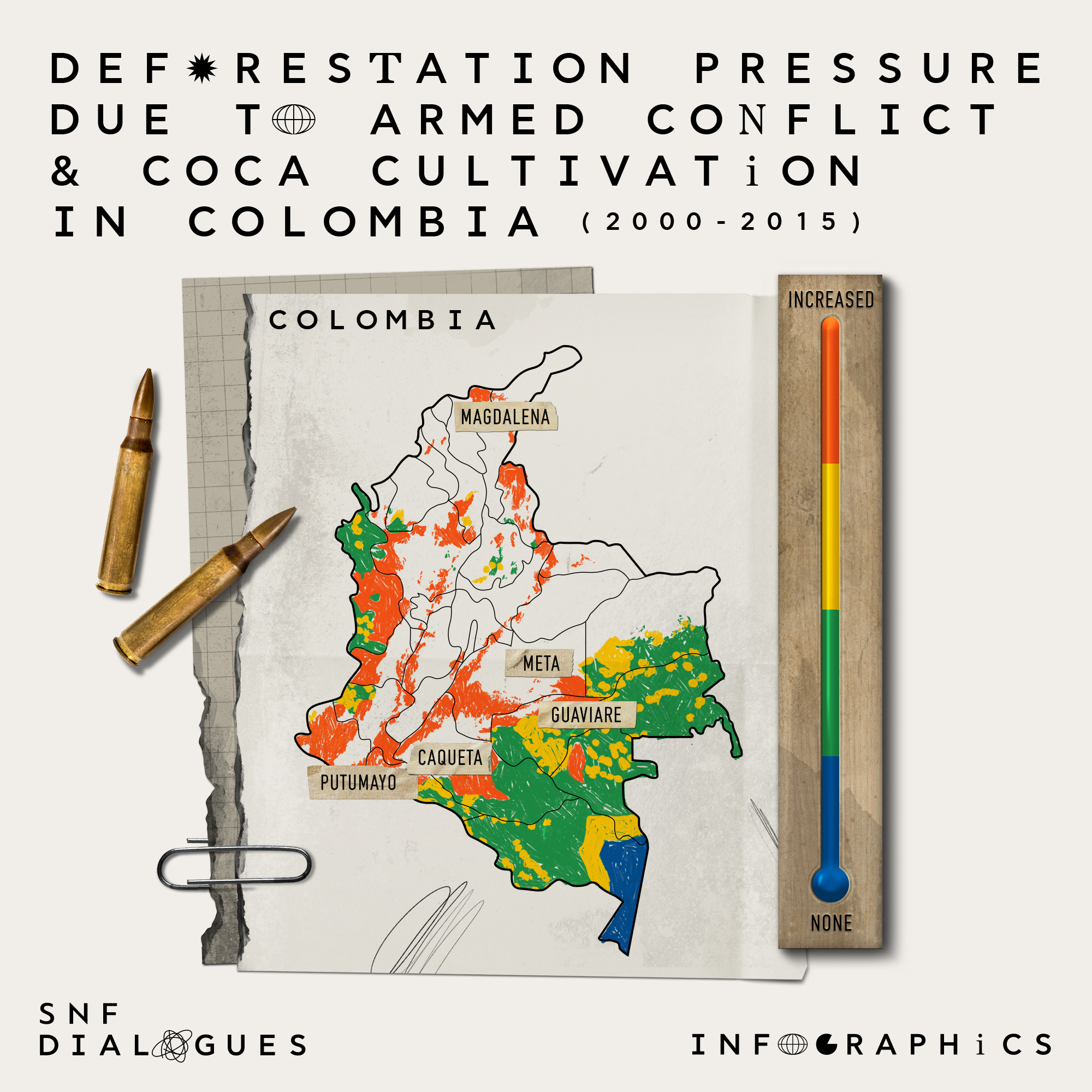
Map 5: Deforestation pressure due to armed conflict and coca cultivation in Colombian departments, in the years between 2000 and 2015. Adapted from Negret et al. (2019).
Regarding the later stages of the drug supply chain, between 2010 and 2020, 16,000 illegal processing sites were destroyed [29] and were forced to dispose 304 million kg of solids and 42 million gallons of liquid chemical precursors into the jungle, which had devastating effects. Nevertheless, the new Colombian President’s Gustavo Petro’s more environmental-centric policies, have caused a historical deforestation decrease. The rate dropped by 29% compared to 2021 and by 36% in the Amazon region [30]. However, unless the War on Drugs is fully over, such efforts will be unsustainable, with forests and Protected Areas still being targeted.
Vietnam
The Vietnam War has been one of the most devastating wars in terms of its consequences on human lives. From 1962 to 1971, 20 million gallons of Agent Orange [31], a defoliant with a dangerous byproduct, dioxin TCDD, were sprayed in Vietnam, Cambodia and Laos leading to soil contamination and long-term human health problems. Operation Ranch Hand, a US herbicide campaign against the Viet Cong, destroyed jungle vegetation that they used as shelter and deprived them of their food supply. More specifically, over 26,300 km2 were sprayed with enormous amounts of herbicides, devastating 15.2% of Southern Vietnam (1,725,400 km2) [32]. Additionally, more than 20,000 km2 of forests were affected, with 90 million m3 of timber and 1500 km2 of mangrove forests being destroyed.
Besides Agent Orange, napalm bombs also caused great damage to Vietnamese ecosystems, especially on the mountains of A Lưới. Paradoxically, the Viet Cong [33] contributed to the vast deforestation of their own land, since they used bombed areas as shelters for inactive bulldozers and the transport of large vehicles.
The Agent Orange application stopped in 1970, with its remnants being stored at the Bien Hoa Airbase and Chemical Corps Operations, while the rest of it was transferred to Atoll Johnson, an island southeast of Hawaii, to be destroyed [34] in 1977 through sea incineration. More than 50 years later, contamination has spread to the human food chain, mainly meat, dairy products, fish and shellfish. Undoubtedly, it will take centuries to regenerate the landscapes that were lost, especially under the existing threat of climate change, making it imperative to hold the perpetrators accountable and restore the ecosystem.
The Gulf War
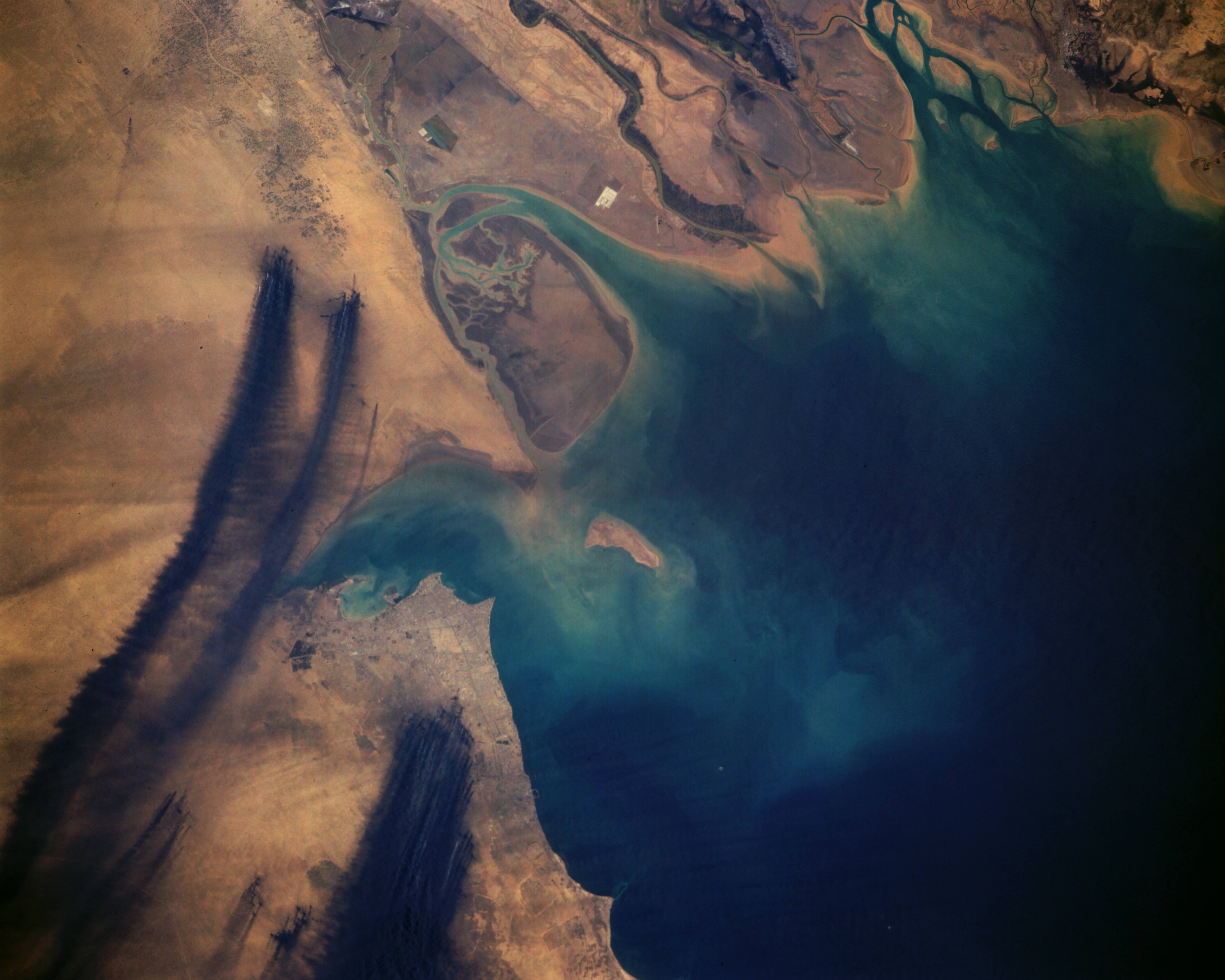
On August 2, 1990, the Gulf War was triggered [35] by Iraq’s invasion of Kuwait due to accusations of Kuwait exporting more oil than the quotas set by the Organization of the Petroleum Exporting Countries. When Iraq retreated from Kuwait on February 28, 1991, it set fire to more than 700 oil wells [36], thus using oil as weapon of war. Consequently, 6 million barrels of oil were burning per day for nearly 10 months. Not only did the oil fires release a substantial 133 million tons of CO2 [37], but they also created a layer of thick smoke as seen below. Fallout from the smoke, created a tar-like deposit, known as tarcrete, over 1,000km2 of Kuwait’s deserts [38].
Photo: NASA photograph from April 7, 1991, depicting fires west of the Tigres and Euphrates deltas and south of Kuwait Bay [39].
Direct release of crude oil from storage units, sabotaged pipelines and oil tankers also caused major damage with 246 oil lakes contaminating 40 million tons of land [40]. Additionally, 11 million barrels spilled into the Persian Gulf, damaging 800 km of coastline. As seen below, after the fires were put out, areas of where the oil wells stood were severely stained by oil residue.
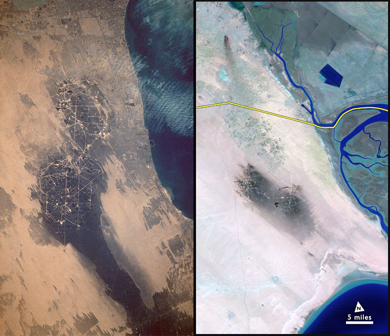
Photo: NASA photograph, from December 1, 1991, depicting the stained area around the Albuoran and Umm Gudair Oil fiels south of Kuwait Bay (left) [41], and NASA Landsat photograph, from 1992, depicting the stained area west of the Tigres and Euphrates deltas (right) [42].
Studies from 2019 [43] showed that contamination in some wellheads ran as deep as 4 meters, and as of 2021, more than 90% of the unprotected contaminated soil remained exposed in the environment. The international community and private corporations are still undertaking “clean-up” programs to remediate the contaminated soil. The UN-mandated Kuwait Environmental Remediation Program, scheduled to be completed in 2028, pledged 3 billion dollars to remediate 26 million m3 of contaminated soil, in 2013. In October 2023, the Kuwait Oil Company signed a $1.7 billion rehabilitation contract [44] making us question whether shareholder and political interests will stall any longer this 31-year-old problem.
Looking forward
The environment must be completely integrated into how we think about warfare. It’s the water we drink, the food we eat, the air we breathe. Sociopolitical developments and the environment are inextricably related. We need sustainable reconstruction models that can establish ecocide in the law, ensure accountability and provide post-conflict technical and financial assistance.
In the words of CEO of Greenpeace Greece [45], Nikos Charalambides, during an interview with the SNF Dialogues team, "at a time of climate crisis and biodiversity destruction, ‘green reconstruction’ initiatives should not be limited or in turn limit climate resilience. This is not a ‘game over’ situation. What we do or do not do today is shaping our near future. We need to be optimistic about the future and escape doomsday narratives".
Credits
Maps: Thanasis Troboukis
Infographics design: Till noon
References
[1] Conflict and Environment Observatory (CEOBS). Available from: https://ceobs.org/
[2] Global Conflict Tracker (2023). War in Ukraine. Available from: https://www.cfr.org/global-conflict-tracker/conflict/conflict-ukraine
[3] De Klerk, L. et al. (2023). Climate damage caused by Russia’s war in Ukraine. Initiative on GHG accounting of war. Available from: https://en.ecoaction.org.ua/wp-content/uploads/2023/06/clim-damage-by-russia-war-12months.pdf
[4] European Commission (2022). Co2 emissions of all world countries: 2022 report. Available from: https://edgar.jrc.ec.europa.eu/report_2022
[5] Zaroda, M. (2023). Navigating The Kakhovka Dam Collapse: NASA Harvest Consortium Assesses Agriculture Impacts With Satellite Imagery. Planet. Available from: https://www.planet.com/pulse/navigating-the-kakhovka-dam-collapse-nasa-harvest-consortium-assesses-agriculture-impacts-with-satellite-imagery/
[6] PAX (2023). A Preliminary Environmental Risk Assessment of the Kakhovka Dam Flooding. Available from: https://paxvoorvrede.nl/wp-content/uploads/2023/06/PAX_REPORT_Kakhovka_FIN.pdf
[7] Ministry of Environmental Protection and Nature Resources of Ukraine (2023). Briefing on the environmental damage caused by Russia’s war of aggression against Ukraine (June 24 – July 5, 2023). Available from: https://ecozagroza.gov.ua/en/feed/2446
[8] PAX (2023)
[9] Stop Ecocide International. Available from: https://www.stopecocide.earth/
[10] European Law Institute (n.d.). Ecocide. Available from: https://www.europeanlawinstitute.eu/projects-publications/completed-projects/ecocide/
[11] Global Forest Watch (2022). Syria. Available from: https://www.globalforestwatch.org/dashboards/country/SYR/?location=WyJjb3VudHJ5IiwiU1lSIl0=&map=eyJjYW5Cb3VuZCI6dHJ1ZX0=
[12]. PAX (2023). Axed and Burned: How Conflict-caused Deforestation Impacts Environmental, Socio-economic and Climate Resilience in Syria. Available from: https://paxforpeace.nl/publications/axed-burned/
[13] Mwayi Mapalunga, A. and Naito, H. (2019). Effect of deforestation on access to clean drinking water. Environmental Sciences, 116 (17), 8249-8254. Available from: https://www.pnas.org/doi/10.1073/pnas.1814970116
[14] IQAair (2023). Air Quality in Syria. Available from: https://www.iqair.com/syria
[15] Ritchie, H. and Rose, M. (2020). Co2 and Greenhouse Gas Emissions. Our World in Data. Available from: https://ourworldindata.org/co2/country/syria?country=~SYR#citation
[16] Syrian Network for Human Rights (SNHR) (2023). The 10th Anniversary of Two Ghoutas Attack: The Largest Chemical Weapons Attack by the Syrian Regime on Syrian Citizens. Available from: https://snhr.org/blog/2023/08/20/the-10th-anniversary-of-two-ghoutas-attack-the-largest-chemical-weapons-attack-by-the-syrian-regime-on-syrian-citizens/
[17] UNOPS (n.d.). Destroying Syria’s Chemical Weapons. Available from: https://www.unops.org/news-and-stories/stories/destroying-syrias-chemical-weapons
[18] WWF Hellas (2014). WWF Ελλάς για την καταστροφή των χημικών όπλων της Συρίας. Available from: https://www.contentarchive.wwf.gr/news/1250-wwf
[19] United Nations Meetings Coverage and Press Releases (2023). Syria’s Chemical Weapons Declaration Still Inaccurate, Unfinished, Top Disarmament Official Tells Security Council, Reiterating Need for Damascus to Fully Cooperate. Available from: https://press.un.org/en/2023/sc15350.doc.htm
[20] Barrera-Ramírez, J., Prado, V. and Solheim, H. (2019). Life cycle assessment and socioeconomic evaluation of the illicit crop substitution policy in Colombia. Journal of Industrial Ecology, 23, 1237-1252. Available from: https://onlinelibrary.wiley.com/doi/abs/10.1111/jiec.12917
[21] Cosoy, N. (2016). Has Plan Colombia really worked? BBC. Available from: https://www.bbc.com/news/world-latin-america-35491504
[22] Molina, M. (2022). Drivers of deforestation in the Colombian Amazon: cattle ranching. National Committee of the Netherlands. Available from: https://www.iucn.nl/en/publication/drivers-of-deforestation-in-the-colombian-amazon-cattle-ranching/
[23] Lopera-Molano, D. and Lopera-Molano, A.M. (2020). Designing communities in peace: Participatory action-research approaches embedded in regional education in Colombia. International Journal of Community Research and Engagement, 13 (1), 1-16. Available from: https://www.researchgate.net/publication/342101116_Designing_communities_in_peace_Participatory_action-research_approaches_embedded_in_regional_education_in_Colombia
[24] The Global Initiative Against Transnational Organized Crime (2016). Organized Crime and Illegally Mined Gold in Latin America. Available from: https://globalinitiative.net/wp-content/uploads/2016/03/Organized-Crime-and-Illegally-Mined-Gold-in-Latin-America.pdf
[25] United Nations Office on Drugs and Crime (2023). World Drug Report. Chapter 4: The nexus between drugs and crimes that affect the environment and convergent crime in the Amazon Basin. Available from: https://www.unodc.org/res/WDR-2023/WDR23_B3_CH4_Amazon.pdf
[26] Clerici, N. et al. (2020). Deforestation in Colombian protected areas increased during post-confict periods. Scientific Reports, 10 (4971). Available from: https://www.nature.com/articles/s41598-020-61861-y
[27] We Stand for Wildlife Colombia (2020). Deforestation Increased in National Protected Areas During the Post-conflict. Available from: https://colombia.wcs.org/en-us/WCS-Colombia/News/articleType/ArticleView/articleId/14110/DEFORESTATION-INCREASED-IN-NATIONAL-PROTECTED-AREAS-DURING-THE-POST-CONFLICT.aspx
[28] Negret, P.J. et al. (2019). Emerging evidence that armed conflict and coca cultivation influence deforestation patterns. Biological Conservation, 239. Available from: https://www.researchgate.net/publication/335129251_Emerging_evidence_that_armed_conflict_and_coca_cultivation_influence_deforestation_patterns
[29] Del Guaviare, S.J. (2023). Colombia’s forests, silent victims of the war on drugs. El País. Available from: https://english.elpais.com/international/2023-06-24/colombias-forests-silent-victims-of-the-war-on-drugs.html)
[30] Noriega, S. (2023). The secret to Colombia’s drop in deforestation? Armed groups. Al Jazeera. Available from: https://www.aljazeera.com/news/2023/8/22/the-secret-to-colombias-drop-in-deforestation-armed-groups
[31] Fuller, T. (2012). 4 Decades on, U.S. Starts Cleanup of Agent Orange in Vietnam. The New York Times. Available from: https://www.nytimes.com/2012/08/10/world/asia/us-moves-to-address-agent-orange-contamination-in-vietnam.html
[32] Nguyen, X. N. et al. (2013). Project “Environmental Remediation of Dioxin Contaminated Hotspots in Vietnam”. Comprehensive Report. Agent Orange/dioxin contamination at three hotspots: Bien Hoa, Da Nang and Phu Cat Airbases. Ministry of Natural Resources and Environment Office of National Steering Committee. Available from: https://vietnam.un.org/sites/default/files/2019-08/CTT%20Tieng%20Anh_resize.pdf
[33] Robert, A. (2016). At the Heart of the Vietnam War: Herbicides, Napalm and Bulldozers Against the A Lưới Mountains. Journal of Alpine Research, 104 (1). Available from: https://journals.openedition.org/rga/3266
[34] Ray Olson, K. and Morton, L.W. (2019). Long-Term Fate of Agent Orange and Dioxin TCDD Contaminated Soils and Sediments in Vietnam Hotspots. Open Journal of Soil Science, 9(1). Available from: https://www.scirp.org/journal/paperinformation?paperid=90675
[35] Britannica (2023). Persian Gulf War: 1990-1991. Available from: https://www.britannica.com/event/Persian-Gulf-War
[36] CEOBS (2016). What the environmental legacy of the Gulf War should teach us. Available from: https://ceobs.org/what-the-environmental-legacy-of-the-gulf-war-should-teach-us/
[37] Stan. A.M. (2021). Environmental warfare and the meaning of long-lasting, widespread, and severe effects in the law of armed conflict. Thesis. Johannes Kepler University Linz. Available from: https://epub.jku.at/obvulihs/download/pdf/6261101?originalFilename=true
[38] CEOBS, 2016
[39] Gateway to Astronaut Photography of Earth (1991). STS037-152-91. Available from: https://eol.jsc.nasa.gov/SearchPhotos/photo.pl?mission=STS037&roll=152&frame=91
[40] Chabert, V. (2022). Environmental protection in armed conflicts: Iraq and the First Gulf War. Opinio Juris. Available from: https://www.opiniojuris.it/environmental-protection-in-armed-conflicts-iraq-and-the-first-gulf-war/
[41] Gateway to Astronaut Photography of Earth (1991). STS044-75-27. Available from: https://eol.jsc.nasa.gov/SearchPhotos/photo.pl?mission=STS044&roll=75&frame=27
[42] NASA (2012). Landsat at 40: The Long View of Earth from Space. Available from: https://d9-wret.s3.us-west-2.amazonaws.com/assets/palladium/production/s3fs-public/atoms/files/2012%20Landsat%20%20at%2040%20Top%2010%20Images%20Brochure.pdf
[43] Syal, R. (2021). ‘Gushing oil and roaring fires’: 30 years on Kuwait is still scarred by catastrophic pollution. The Guardian. Available from: https://www.theguardian.com/environment/2021/dec/11/the-sound-of-roaring-fires-is-still-in-my-memory-30-years-on-from-kuwaits-oil-blazes
[44] Hagagy, A. (2023). Kuwait Oil Company signs $1.7 bln soil-rehab contracts – document. Reuters. Available from: https://www.reuters.com/business/energy/kuwait-oil-company-signs-17-bln-soil-rehab-contracts-document-2023-10-18/
[45] Greenpeace Greece. Available from: https://www.greenpeace.org/greece/
*The opinions expressed by Dialogues participants, whether representing officially institutions and organizations or themselves, on events, articles, or other audiovisual media are solely their own and do not necessarily represent the views of the Stavros Niarchos Foundation (SNF) or iMEdD. Opinions are made freely, without prior guidance or intervention from the team.